The Radcliffe Line was the boundary demarcated by the two boundary
commissions for the provinces ofPunjab andBengal during
thePartition
of India. It is named after Cyril
Radcliffe, who, as the joint chairman of the two boundary commissions,
had the ultimate responsibility to equitably divide 175,000 square miles
(450,000 km2) of
territory with 88 million people.
The term "Radcliffe Line" is also sometimes used for the entire boundary
between India and Pakistan. However, outside of Punjab and Bengal, the
boundary is made of existing provincial boundaries and had nothing to do
with the Radcliffe commissions.
The demarcation line was published on 17 August 1947, two days after the
independence of Pakistan and India. Today, the Punjab part of the line is
part of the India–Pakistan
border while the Bengal part of the line serves as theBangladesh–India
border.
Background
Events leading up to the Radcliffe Boundary Commissions
Map illustrating the overall framework of partition. Daily
Herald newspaper, 4th June 1947.
On 18 July 1947, the Indian
Independence Act 1947 of the Parliament of the United Kingdom
stipulated that British rule in India would come to an end just one month
later, on 15 August 1947. The Act also stipulated the partition of thePresidencies
and provinces of British India into two new sovereigndominions:
India and Pakistan.
Pakistan was intended as a Muslim homeland, while India remained secular.
Muslim-majority British provinces in the northwest were to become the
foundation of Pakistan. The provinces of Baluchistan (91.8%
Muslim before partition) andSindh (72.7%)
andNorth-West
Frontier Province became entirely Pakistani territory. However, two
provinces did not have an overwhelming Muslim majority—Punjab in
the northwest (55.7% Muslim) andBengal in
the northeast (54.4% Muslim). After
elaborate discussions, these two provinces ended up being partitioned
between India and Pakistan.
The Punjab's population distribution was such that there was no line that
could neatly divide the Hindus, Muslims,
and Sikhs.
Likewise, no line could appease both the Muslim
League, headed by Jinnah,
and the Congress led
byJawaharlal
Nehru andVallabhbhai
Patel.[citation
needed] Moreover, any division based on religious
communities was sure to entail "cutting through road and rail
communications, irrigation schemes, electric power systems and even
individual landholdings."
Prior ideas of partition
The idea of partitioning the provinces of Bengal and Punjab had been
present since the beginning of the 20th century. Bengal had in fact been partitioned by
the then viceroyLord
Curzon in 1905, along with its adjoining regions. The resulting
'Eastern Bengal and Assam' province, with its capital atDhaka,
had a Muslim majority and the 'West Bengal' province, with its capital at Calcutta,
had a Hindu majority. However, this partition of Bengal was reversed in
1911 in an effort to mollify Bengali
nationalism. Proposals for partitioning Punjab had been made starting
in 1908. Its proponents included the Hindu leader Bhai Parmanand, Congress
leader Lala Lajpat Rai, industrialist G. D. Birla, and various Sikh
leaders. After the 1940 Lahore
resolution of the Muslim League demanding Pakistan,B. R.
Ambedkar wrote a 400-page tract titledThoughts on
Pakistan. In the tract, he discussed the boundaries of Muslim and
non-Muslim regions of Punjab and Bengal. His calculations showed a Muslim
majority in 16 western districts of Punjab and non-Muslim majority in 13
eastern districts. In Bengal, he showed non-Muslim majority in 15
districts. He thought the Muslims could have no objection to redrawing
provincial boundaries. If they did, "they [did] not understand the nature
of their own demand"
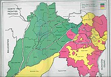
Districts of Punjab with Muslim (green) and non-Muslim (pink) majorities,
as per 1941 census
After the breakdown of the 1945 Simla Conference of viceroyLord
Wavell, the idea of Pakistan began to be contemplated seriously. Sir Evan
Jenkins, the private secretary of the viceroy (later the governor of
Punjab), wrote a memorandum titled "Pakistan and the Punjab", where he
discussed the issues surrounding the partition of Punjab. K. M. Panikkar,
then prime minister of the Bikaner State, sent a memorandum to the viceroy
titled "Next Step in India", wherein he recommended that the principle of
'Muslim homeland' be conceded but territorial adjustments made to the two
provinces to meet the claims of the Hindus and Sikhs. Based on these
discussions, the viceroy sent a note on the "Pakistan theory" to
the Secretary of State for India. The viceroy informed the Secretary of
State that Jinnah envisaged thefull provinces of
Bengal and Punjab going to Pakistan with only minor adjustments, whereas
Congress was expectingalmost half of these provinces
to remain in India. This essentially framed the problem of partition.
The Secretary of State responded by directing Lord Wavell to send 'actual
proposals for defining genuine Muslim areas'. The task fell on V. P.
Menon, the Reforms Commissioner, and his colleague Sir B. N. Rau in the
Reforms Office. They prepared a note called "Demarcation of Pakistan
Areas", where they included the three western divisions of Punjab
(Rawalpindi, Multan and Lahore) in Pakistan, leaving two eastern divisions
of Punjab in India (Jullundur and Delhi). However, they noted that this
allocation would leave 2.2 million Sikhs in the Pakistan area and about
1.5 million in India. Excluding the Amritsar andGurdaspur districts
of the Lahore Division from Pakistan would put a majority of Sikhs in
India. (Amritsar had a non-Muslim majority and Gurdaspur a marginal Muslim
majority.) To compensate for the exclusion of the Gurdaspur district, they
included the entireDinajpur district in the eastern zone of
Pakistan, which similarly had a marginal Muslim majority. After receiving
comments from John Thorne, member of the Executive Council in charge of
Home affairs, Wavell forwarded the proposal to the Secretary of State. He
justified the exclusion of the Amritsar district because of its sacredness
to the Sikhs and that of Gurdaspur district because it had to go with
Amritsar for 'geographical reasons'. The Secretary of State commended the
proposal and forwarded it to the India and Burma Committee, saying, "I do
not think that any better division than the one the Viceroy proposes is
likely to be found".
Sikh concerns
The Sikh leader Master Tara Singh could see that any division of Punjab
would leave the Sikhs divided between Pakistan and Hindustan. He espoused
the doctrine of self-reliance,opposed the partition of
India and called for independence on the grounds that no single religious
community should control Punjab. Other Sikhs argued that just as Muslims
feared Hindu domination the Sikhs also feared Muslim domination. Sikhs
warned the British government that the morale of Sikh troops in the
British Army would be affected if Pakistan was forced on them.Gianni
Kartar Singh drafted a scheme of a separate Sikh state if India was to be
divided.
During the Partition developments, Jinnah offered Sikhs to live in
Pakistan with safeguards for their rights. Sikhs refused because they
opposed the concept of Pakistan and also because they did not want to
become a small minority within a Muslim majority. Vir Singh Bhatti
distributed pamphlets for the creation of a separate Sikh state
"Khalistan". Master Tara Singh wanted the right for an independent
Khalistan to federate with either Hindustan or Pakistan. However, the Sikh
state being proposed was for an area where neither religion was in
absolute majority. Negotiations for the independent Sikh state had
commenced at the end of World War II and the British initially agreed but
the Sikhs withdrew this demand after pressure from Indian
nationalists. The proposals of the Cabinet Mission Plan had seriously
jolted the Sikhs because while both the Congress and League could be
satisfied the Sikhs saw nothing in it for themselves. as they would be
subjected to a Muslim majority. Master Tara Singh protested this to
Pethic-Lawrence on 5 May. By early September the Sikh leaders accepted
both the long term and interim proposals despite their earlier
rejection. The Sikhs attached themselves to the Indian state with the
promise of religious and cultural autonomy.
Final negotiations
Pre-partition Punjab province
In March 1946, the British government sent a Cabinet Mission to India to
find a solution to resolve the conflicting demands of Congress and the
Muslim League. Congress agreed to allow Pakistan to be formed with
'genuine Muslim areas'. The Sikh leaders asked for a Sikh state withAmbala, Jalandher, Lahore Divisions
with some districts from theMultan Division, which, however,
did not meet the Cabinet delegates' agreement. In discussions with Jinnah,
the Cabinet Mission offered either a 'smaller Pakistan' with all the
Muslim-majority districts except Gurdaspur or a 'larger Pakistan'
under the sovereignty of the Indian Union. The Cabinet Mission came close
to success with its proposal for an Indian Union under a federal scheme,
but it fell apart in the end because of Nehru's opposition to a heavily
decentralised India.
In March 1947, Lord Mountbatten arrived in India as the next viceroy, with
an explicit mandate to achieve the transfer of power before June 1948.
Over ten days, Mountbatten obtained the agreement of Congress to the
Pakistan demand except for the 13 eastern districts of Punjab (including
Amritsar and Gurdaspur). However, Jinnah held out. Through a series of six
meetings with Mountbatten, he continued to maintain that his demand was
for six full provinces. He "bitterly complained" that the Viceroy was
ruining his Pakistan by cutting Punjab and Bengal in half as this would
mean a 'moth-eaten Pakistan'.
The Gurdaspur district remained a key contentious issue for the
non-Muslims. Their members of the Punjab legislature made representations
to Mountbatten's chief of staff Lord Ismay as well as the Governor telling
them that Gurdaspur was a "non-Muslim district". They contended that even
if it had a marginal Muslim majority of 51%, which they believed to be
erroneous, the Muslims paid only 35% of the land revenue in the district.
In April, the Governor of Punjab Evan Jenkins wrote a note to Mountbatten
proposing that Punjab be divided along Muslim and non-Muslim majority
districts and proposed that a Boundary Commission be set up consisting of
two Muslim and two non-Muslim members recommended by the Punjab
Legislative Assembly. He also proposed that a British judge of the High
Court be appointed as the chairman of the commission. Jinnah and the
Muslim League continued to oppose the idea of partitioning the provinces,
and the Sikhs were disturbed about the possibility of getting only 12
districts (without Gurdaspur). In this context, the Partition Plan of 3
June was announced with a notional partition showing 17 districts of
Punjab in Pakistan and 12 districts in India, along with the establishment
of a Boundary Commission to decide the final boundary. In Sialkoti's view,
this was done mainly to placate the Sikhs.
Process and key people
A crude border had already been drawn up by Lord
Wavell, the Viceroy
of India prior to his replacement as Viceroy, in February 1947, byLord
Louis Mountbatten. In order to determine exactly which territories to
assign to each country, in June 1947, Britain appointedSir
Cyril Radcliffe to chair two boundary commissions—one for Bengal and
one for Punjab.
The commission was instructed to "demarcate the boundaries of the two
parts of the Punjab on the basis of ascertaining the contiguous majority
areas of Muslims and non-Muslims. In doing so, it will also take into
account other factors. Other factors were undefined, giving Radcliffe
leeway, but included decisions regarding "natural boundaries,
communications, watercourses and irrigation systems", as well as
socio-political consideration. Each commission also had four
representatives—two from theIndian
National Congress and two from theMuslim
League. Given the deadlock between the interests of the two sides and
their rancorous relationship, the final decision was essentially
Radcliffe's.
After arriving in India on 8 July 1947, Radcliffe was given just five
weeks to decide on a border. He soon met with his fellow college alumnus
Mountbatten and travelled toLahore andCalcutta to
meet with commission members, chiefly Nehru from the Congress and Jinnah,
president of the Muslim League. He objected to the short time frame, but
all parties were insistent that the line be finished by the 15 August
British withdrawal from India. Mountbatten had accepted the post as
Viceroy on the condition of an early deadline. The decision was completed
just a couple of days before the withdrawal, but due to political
considerations, not published until 17 August 1947, two days after the
grant of independence to India and Pakistan.
Members of the commissions
Each boundary commission consisted of five people – a chairman (Radcliffe),
two members nominated by the Indian National Congress and two members
nominated by theMuslim League.
The Bengal Boundary Commission consisted of justices C. C. Biswas, B. K.
Mukherji, Abu Saleh Mohamed Akram andS.A.Rahman.
The members of the Punjab Commission were justices Mehr Chand Mahajan,
Teja Singh, Din Mohamed and Muhammad Munir.
Problems in the process
Boundary-making procedures
The Punjabi section of the Radcliffe Line
All lawyers by profession, Radcliffe and the other commissioners had all
of the polish and none of the specialized knowledge needed for the task.
They had no advisers to inform them of the well-established procedures and
information needed to draw a boundary. Nor was there time to gather the
survey and regional information. The absence of some experts and advisers,
such as the United Nations, was deliberate, to avoid delay. Britain's new
Labour government "deep in wartime debt, simply couldn't afford to hold on
to its increasingly unstable empire. "The absence of outside
participants—for example, from the United Nations—also satisfied the
British Government's urgent desire to save face by avoiding the appearance
that it required outside help to govern—or stop governing—its own empire.
Political representation
The equal representation given to politicians from Indian National
Congress and the Muslim League appeared to provide balance, but instead
created deadlock. The relationships were so tendentious that the judges
"could hardly bear to speak to each other", and the agendas so at odds
that there seemed to be little point anyway. Even worse, "the wife and two
children of the Sikh judge in Lahore had been murdered by Muslims in
Rawalpindi a few weeks earlier.
In fact, minimizing the numbers of Hindus and Muslims on the wrong side of
the line was not the only concern to balance. The Punjab Border Commission
was to draw a border through the middle of an area home to the Sikh
community. Lord Islay was rueful for the British not to give more
consideration to the community who, in his words, had "provided many
thousands of splendid recruits for the Indian Army" in its service for the
crown in World War I However, the Sikhs were militant in their opposition
to any solution which would put their community in a Muslim ruled state.
Moreover, many insisted on their own sovereign state, something no one
else would agree to.
Last of all, were the communities without any representation. The Bengal
Border Commission representatives were chiefly concerned with the question
of who would get Calcutta. The Buddhist tribes in the Chittagong Hill
Tracts in Bengal had no official representation and were left totally
without information to prepare for their situation until two days after
the partition.
Perceiving the situation as intractable and urgent, Radcliffe went on to
make all the difficult decisions himself. This was impossible from
inception, but Radcliffe seems to have had no doubt in himself and raised
no official complaint or proposal to change the circumstances.
Local knowledge
Before his appointment, Radcliffe had never visited India and knew no one
there. To the British and the feuding politicians alike, this neutrality
was looked upon as an asset; he was considered to be unbiased toward any
of the parties, except of course Britain. Only his private secretary,
Christopher Beaumont, was familiar with the administration and life in
Punjab. Wanting to preserve the appearance of impartiality, Radcliffe also
kept his distance fromViceroy Mountbatten.
No amount of knowledge could produce a line that would completely avoid
conflict; already, "sectarian riots in Punjab and Bengal dimmed hopes for
a quick and dignified British withdrawal". "Many of the seeds of
postcolonial disorder in South Asia were sown much earlier, in a century
and half of direct and indirect British control of large part of the
region, but, as book after book has demonstrated, nothing in the complex
tragedy of partition was inevitable."[
Haste and indifference
Radcliffe justified the casual division with the truism that no matter
what he did, people would suffer. The thinking behind this justification
may never be known since Radcliffe "destroyed all his papers before he
left India". He departed on Independence Day itself, before even the
boundary awards were distributed. By his own admission, Radcliffe was
heavily influenced by his lack of fitness for the Indian climate and his
eagerness to depart India.
The implementation was no less hasty than the process of drawing the
border. On 16 August 1947 at 5:00 pm, the Indian and Pakistani
representatives were given two hours to study copies, before the Radcliffe
award was published on 17 August.
Secrecy
To avoid disputes and delays, the division was done in secret. The final
Awards were ready on 9 and 12 August, but not published until two days
after the partition.
According to Read and Fisher, there is some circumstantial evidence that
Nehru and Patel were secretly informed of the Punjab Award's contents on 9
or 10 August, either through Mountbatten or Radcliffe's Indian assistant
secretary. Regardless of how it transpired, the award was changed to put a
salient portion of the non-Muslim majorityFirozpur
district (consisting of the two Muslim-majoritytehsils ofFirozpur andZira)
east of the Sutlej canal within India's domain instead of
Pakistan's. There were two apparent reasons for the switch: the area
housed an army arms depot, and contained the headwaters of a canal which
irrigated the princely state of Bikaner, which would accede to India.
Implementation
After the partition, the fledgling governments of India and Pakistan were
left with all responsibility to implement the border. After visiting
Lahore in August, Viceroy Mountbatten hastily arranged a Punjab Boundary
Force to keep the peace around Lahore, but 50,000 men was not enough to
prevent thousands of killings, 77% of which were in the rural areas. Given
the size of the territory, the force amounted to less than one soldier per
square mile. This was not enough to protect the cities much less the
caravans of the hundreds of thousands of refugees who were fleeing their
homes in what would become Pakistan.
Both India and Pakistan were loath to violate the agreement by supporting
the rebellions of villages drawn on the wrong side of the border, as this
could prompt a loss of face on the international stage and require the
British or the UN to intervene. Border conflicts led to three wars, in 1947, 1965,
and 1971,
and the Kargil conflict of 1999.
Disputes along the Radcliffe Line
There were disputes regarding the Radcliffe Line's award of the Chittagong
Hill Tracts and theGurdaspur district. Disputes also evolved
around the districts of Malda, Khulna, and Murshidabad in Bengal and the
sub-division ofKarimganj of Assam.
In addition to Gurdaspur's Muslim majority tehsils, Radcliffe also gave
the Muslim majority tehsils of Ajnala (Amritsar District), Zira, Firozpur
(in Firozpur District), Nakodar and Jullandur (in Jullandur District) to
India instead of Pakistan.
Indian historians now accept that Mountbatten probably did influence the
Firozpur award in India's favour. The headworks of River Beas, which later
joins River Sutlej flowing into Pakistan, were located in Firozpur.
Congress leader Nehru and Viceroy Mountbatten had lobbied Radcliffe that
headworks should not go to Pakistan.
Populations of Muslim and Non-Muslims in Gurdaspur District, based on
Census Data. In the 1881 Census, Non-Muslims were in majority, at 52.49%.
The proportion of the Muslim population increased in the following
decades, turning them into a majority by the 1930s.[61]
The Gurdaspur district was divided geographically by the Ravi River, with
the Shakargarh tehsil on its west bank, andPathankot, Gurdaspur
and Batala tehsils on its east bank. The Shakargarh tehsil, the biggest in
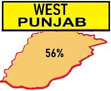
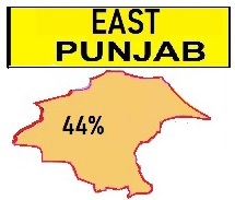
size, was awarded to Pakistan. (It was subsequently merged into theNarowal
district ofWest Punjab.[62])
The three eastern tehsils were awarded to India. (Pathankot was eventually
made a separate district in East Punjab.) The division of the district was
followed by a population transfer between the two nations, with Muslims
leaving for Pakistan and Hindus and Sikhs arriving from there.
The entire district of Gurdaspur had a bare majority of 50.2% Muslims. (In
the 'notional' award attached to the Indian Independence Act, all of
Gurdaspur district was marked as Pakistan with a 51.14% Muslim
majority. In the 1901 census, the population of Gurdaspur district was 49%
Muslim, 40% Hindu, and 10% Sikh.) The Pathankot tehsil was predominantly
Hindu while the other three tehsils were Muslim majority. In the event,
only Shakargarh was awarded to Pakistan.
Radcliffe explained that the reason for deviating from the notional award
in the case of Gurdaspur was that the headwaters of thecanals that
irrigated the Amritsar district lay in the Gurdaspur district and it was
important to keep them under one administration.[64] Radcliffe
might have sided with Lord Wavell's reasoning from February 1946 that
Gurdaspur had to go with the Amritsar district, and the latter could not
be in Pakistan due to its Sikh religious shrines. In addition, the railway
line from Amritsar to Pathankot passed through the Batala and Gurdaspur
tehsils.[68]
Pakistanis have alleged that the award of the three tehsils to India was a
manipulation of the Award by Lord Mountbatten in an effort to provide a
land route for India to Jammu and Kashmir.[63] However,
Shereen Ilahi points out that the land route to Kashmir was entirely
within the Hindu-majority Pathankot tehsil. The award of the Batala and
Gurdaspur tehsils to India did not affect the Kashmir land route.
Pakistani view on the award of Gurdaspur to India
Pakistan maintains that the Radcliffe Award was altered by Mountbatten;
Gurdaspur was handed over to India and thus was manipulated the accession
of Kashmir to India. In support of this view, some scholars claim the
award to India "had little to do with Sikh demands but had much more to do
with providing India a road link to Jammu and Kashmir.
As per the 'notional' award that had already been put into effect for
purposes of administration ad interim, all of Gurdaspur district, owing to
its Muslim majority, was assigned to Pakistan. From 14 to 17 August,
Mushtaq Ahmed Cheema acted as theDeputy Commissioner of the
Gurdaspur District, but when, after a delay of two days, it was announced
that the major portion of the district had been awarded to India instead
of Pakistan, Cheema left for Pakistan. The
major part of Gurdaspur district, i.e. three of the four sub-districts had
been handed over to India giving India practical land access to Kashmir.. It
came as a great blow to Pakistan. Jinnah and other leaders of Pakistan,
and particularly its officials, criticized the award as 'extremely unjust
and unfair'.
Muhammad Zafarullah Khan, who represented the Muslim League in July 1947
before the Radcliffe Boundary Commission, stated that the boundary
commission was a farce. A secret deal between Mountbatten and Congress
leaders had already been struck. Mehr Chand Mahajan, one of the two
non-Muslim members of the boundary commission, in his autobiography, has
acknowledged that when he was selected for the boundary commission, he was
not inclined to accept the invitation as he believed that the commission
was just a farce and that decisions were actually to be taken by
Mountbatten himself. It
was only under British pressure that the charges against Mountbatten of
last minute alterations in the Radcliffe Award were not officially brought
forward by Pakistani Government in the UN Security Council while
presenting its case on Kashmir.
Zafrullah Khan states that, in fact, adopting the tehsil as a unit would
have given Pakistan the Firozepur and Zira tehsils of the Firozpur
District, the Jullundur and Nakodar tehsils of Jullundur district and the
Dasuya tehsil of the Hoshiarpur district. The line so drawn would also
give Pakistan the princely state of Kapurthala(which had a Muslim majority) and would enclose
within Pakistan the whole of the Amritsar district of which only one
tehsil, Ajnala, had a Muslim majority. It would also give Pakistan the
Shakargarh, Batala and Gurdaspur tehsils of the Gurdaspur district. If the
boundary went by Doabs, Pakistan could get not only the 16 districts which
had already under the notional partition been put into West Punjab,
including the Gurdaspur District, but also get the Kangra District in the
mountains, which was about 93% Hindu and was located to the north and east
of Gurdaspur. Or one could go by commissioners' divisions. Any of these
units being adopted would have been more favourable to Pakistan than the
present boundary line. The tehsil was the most favourable unit. But
all of the aforementioned Muslim majority tehsils, with the exception of
Shakargarh, were handed over to India while Pakistan didn't receive any
Non-Muslim majority district or tehsil in Punjab. Zafruallh
Khan states that Radcliffe used district, tehsil, thana, and even village
boundaries to divide Punjab in such a way that the boundary line was drawn
much to the prejudice of Pakistan. However, while Muslims formed about 53%
of the total population of Punjab in 1941, Pakistan received around 58% of
the total area of the Punjab, including more of the most fertile parts.
According to Zafrullah Khan, the assertion that the award of the Batala
and Gurdaspur tehsils to India did not 'affect' Kashmir is far-fetched. If
Batala and Gurdaspur had gone to Pakistan, Pathankot tehsil would have
been isolated and blocked. Even though it would have been possible for
India to get access to Pathankot through the Hoshiarpur district, it would
have taken quite long time to construct the roads, bridges and
communications that would have been necessary for military movements.
Assessments on the 'Controversial Award of Gurdaspur to India and the
Kashmir Dispute'
Stanley Wolpert writes that Radcliffe in his initial maps awarded
Gurdaspur district to Pakistan but one of Nehru's and Mountbatten's
greatest concerns over the new Punjab border was to make sure that
Gurdaspur would not go to Pakistan, since that would have deprived India
of direct road access to Kashmir. As
per "The Different Aspects of Islamic Culture", a part ofUNESCO's
Histories flagship project, recently disclosed documents of the history of
the partition reveal British complicity with the top Indian leadership to
wrest Kashmir from Pakistan. Alastair Lamb, based on the study of recently
declassified documents, has convincingly proven that Mountbatten, in
league with Nehru, was instrumental in pressurizing Radcliffe to award the
Muslim-majority district of Gurdaspur in East Punjab to India which could
provide India with the only possible access to Kashmir. Andrew
Roberts believes that Mountbatten cheated over India-Pak frontier and
states that if gerrymandering took place in the case of Firozepur, it is
not too hard to believe that Mountbatten also pressurized Radcliffe to
ensure that Gurdaspur wound up in India to give India road access to
Kashmir.
Perry Anderson states that Mountbatten, who was officially supposed to
neither exercise any influence on Radcliffe nor to have any knowledge of
his findings, intervened behind the scenes – probably at Nehru's behest –
to alter the award. He had little difficulty in getting Radcliffe to
change his boundaries to allot the Muslim-majority district of Gurdaspur
to India instead of Pakistan, thus giving India the only road access from
Delhi to Kashmir.
However, some British works suggest that the 'Kashmir State was not in
anybody's mind when the Award was being drawn and that even the Pakistanis
themselves had not realized the importance of Gurdaspur to Kashmir until
the Indian forces actually entered Kashmir. Both
Mountbatten and Radcliffe, of course, have strongly denied those charges.
It is impossible to accurately quantify the personal responsibility for
the tragedy of Kashmir as the Mountbatten papers relating to the issue at
the India Office Library and records are closed to scholars for an
indefinite period.
The Chittagong Hill Tracts (CHT) had a majority non-Muslim population of
97% (most of themBuddhists), but was given to Pakistan.
The Chittagong Hill Tracts People's Association (CHTPA) petitioned the
Bengal Boundary Commission that, since the CHTs were inhabited largely
by non-Muslims, they should remain within India. The Chittagong Hill
Tracts was an excluded area since 1900 and was not part of Bengal. It
had no representative at the Bengal Legislative Assembly in Calcutta,
since it was not part of Bengal. Since they had no official
representation, there was no official discussion on the matter, and many
on the Indian side assumed the CHT would be awarded to India.
On 15 August 1947, Chakma and other indigenous Buddhists celebrated
independence day by hoisting the Indian flag in Rangamati, the capital
of Chittagong Hill Tracts. When the boundaries of Pakistan and India
were announced by radio on 17 August 1947, they were shocked to know
that the Chittagong Hill Tracts had been awarded to Pakistan. The Baluch
Regiment of the Pakistani Army entered Chittagong Hill Tracts a week
later and lowered the Indian flag at gun point. The rationale of giving
the Chittagong Hill Tracts to Pakistan was that they were inaccessible
to India and to provide a substantial ruralbuffer to
supportChittagong (now inBangladesh), a
major city and port; advocates for Pakistan forcefully argued to the
Bengal Boundary Commission that the only approach was through
Chittagong.
The indigenous people sent a delegation led by Sneha Kumar Chakma to
Delhi to seek help from the Indian leadership. Sneha Kumar Chakma
contacted Sardar Patel by phone. Sardar Patel was willing to help, but
insisted Sneha Kumar Chakma seek assistance from Prime Minister Pandit
Nehru. But Nehru refused to help fearing that military conflict for
Chittagong Hill Tracts might draw the British back to India.
Malda District
Another disputed decision made by Radcliffe was the division of
the Malda district ofBengal. The district overall had a
slight Muslim majority but was divided and most of it, including Malda
town, went to India. The district remained under East Pakistan
administration for 3–4 days after 15 August 1947. It was only when the
award was made public that the Pakistani flag was replaced by the Indian
flag in Malda.
Khulna and Murshidabad Districts
The Khulna District (with a Hindu majority of 58%) was given to East
Pakistan in lieu of theMurshidabad district (with a 70%
Muslim majority), which went to India. However, the Pakistani flag
remained hoisted in Murshidabad for three days until it was replaced by
the Indian flag on the afternoon of 17 August 1947.
Karimganj
The Sylhet district ofAssam joined Pakistan in accordance
with areferendum.[98] However,
theKarimganj sub-division (with a Muslim majority) was
separated from Sylhet and given to India, where it became a district in
1983. As of the2001 Indian census, Karimganj district now
has a Muslim majority of 52.3%.[99]
Legacy
The Partition of India is one of the central events in the collective
memory in India, Pakistan, and Bangladesh. As a crucial determiner in
the outcomes of the partition, the Radcliffe Line and award process has
been referred to in many films, books, and other artistic depictions of
the Partition of India. Apart from the larger story of the partition,
the specific commemoration of the award itself or the recounting of the
story of the process and the people involved in it has been
comparatively rare.
Legacy and historiography
As a part of a series on borders, the explanatory news site Vox featured
an episode looking at "the ways that the Radcliffe line changed Punjab,
and its everlasting effects" including disrupting "a centuries-old Sikh
pilgrimage" and separating "Punjabi people of all faiths from each
other.
Artistic depictions of the Radcliffe Line
One notable depiction is Drawing the Line, written by British
playwright Howard Brenton. On his motivation for writing the play,
Brenton said he first became interested in the story of the Radcliffe
Line while holidaying in India and hearing stories from people whose
families had fled across the new line.[102] Defending
his portrayal of Cyril Radcliffe as a man who struggled with his
conscience, Brenton said, "There were clues that Radcliffe had a dark
night of the soul in the bungalow: he refused to accept his fee, he did
collect all the papers and draft maps, took them home to England and
burnt them. And he refused to say a word, even to his family, about what
happened. My playwright's brain went into overdrive when I discovered
these details."[102]
Indian filmmaker Ram Madhvani created a nine-minute short film where he
explored the plausible scenario of Radcliffe regretting the line he
drew. The film was inspired byW. H. Auden's poem on the
Partition.[103][104]
Visual artists Zarina Hashmi, Salima
Hashmi, Nalini
Malini, Reena
Saini Kallat andPritika
Chowdhry have
created drawings, prints and sculptures depicting the Radcliffe Line.
Notes
^Schofield, Kashmir in
Conflict (2003, p. 35): Wavell, however, had made a more significant
political judgment in his plan, submitted to the secretary of state,
Lord Pethick-Lawrence, in February 1946: 'Gurdaspur must go with
Amritsar for geographical reasons and Amritsar being sacred city of
Sikhs must stay out of Pakistan... Fact that much of Lahore district
is irrigated from upper Bari Doab canal with headworks in Gurdaspur
district is awkward but there is no solution that avoids all such
difficulties.'
^Princely States were
given the option of either acceding to one of the two countries
(India and Pakistan) or declaring independence. The ruler of
Kapurthala acceded to India.

.jpg)


